.post-body img { max-width:300px; max-height:auto; }

Saturday, September 19, 2015

Wyo Road Trip: 4of4 Southern Wind Rivers; The Cirque of the Towers

We finally made it! With no intentions to climb, Sam and I set out early with light packs to hike into the cirque and check things out. We left the truck with long johns on, stocking hats, warm gloves and puffy jackets! It was no more than 10 degrees when we departed and stayed that way until the sun came up high enough to reach the valley floors between the massive mountains. I did over 5 miles with a down jacket on; I think thats happened while ice climbing in the middle of winter before but never in the middle of September! At Big Sandy Lake the trail forks to either Deep Lake or Lonesome Lake and the cirque. We contemplated hiking the Grassy Goat Trail up Haystack mountain to get a summit but due to the snow we opted out. The Grassy Goat trail splits this huge cliff face on Haystack and I think if there is any chance of it being wet, you stay away. I cant wait to get back and climb it when its dry... spooky! No biggy, we really wanted to see the cirque anyway. A couple of rough miles later we reached Lonesome Lake and the cirque. Wow. We would walk 50 yards and gape at the mountains for 10 minutes. Walk another 50 yards and gape again. It took forever to get anywhere because we couldn't peel our eyes off the mountains. Big, beautiful, scary, climbable, treeless granite spires and buttresses everywhere you look. A climber's dream! It was pretty easy to see the classic East Ridge route going over Wolfshead but we wanted a closer look at the NE face route of Pingora. We traversed Pingora from the base of the South face all the way to the North ridge then traversed over to the start of the route. We were able to watch climbers the whole time. One group was in the process of bailing and Im positive it had to do with the fact that they got a late start and were in the shade and got cold. It was freezing cold in the shade even though there was nothing but sunshine, no wind and no clouds. Any aspect of the mountains that had not received sunshine was covered in verglass. Verglass is a thin coat of ice. I have never seen verglass like this before. A few of the NE face pitches had ice on/in them. After a glorious 17 mile day we finally got to drink the bottle of champagne Sam brought from MT. A great way to toast an epic road trip. No car problems, health problems or law problems.
50+ miles of dirt road to reach the trailhead.
Fat, little legs, long ears, eats all day.... Manfred's previous life!

Preparation MUU style
Big Sandy Peak from the North shore of Big Sandy Lake. 
Our first glimpse of Pingora. 


The Cirque of the Towers!
Pingora is the prominent peak in the middle with Wolfs Head sharing the ridge to the left. Far left is Warbonnet?
Walking up to the South face of Pingora.

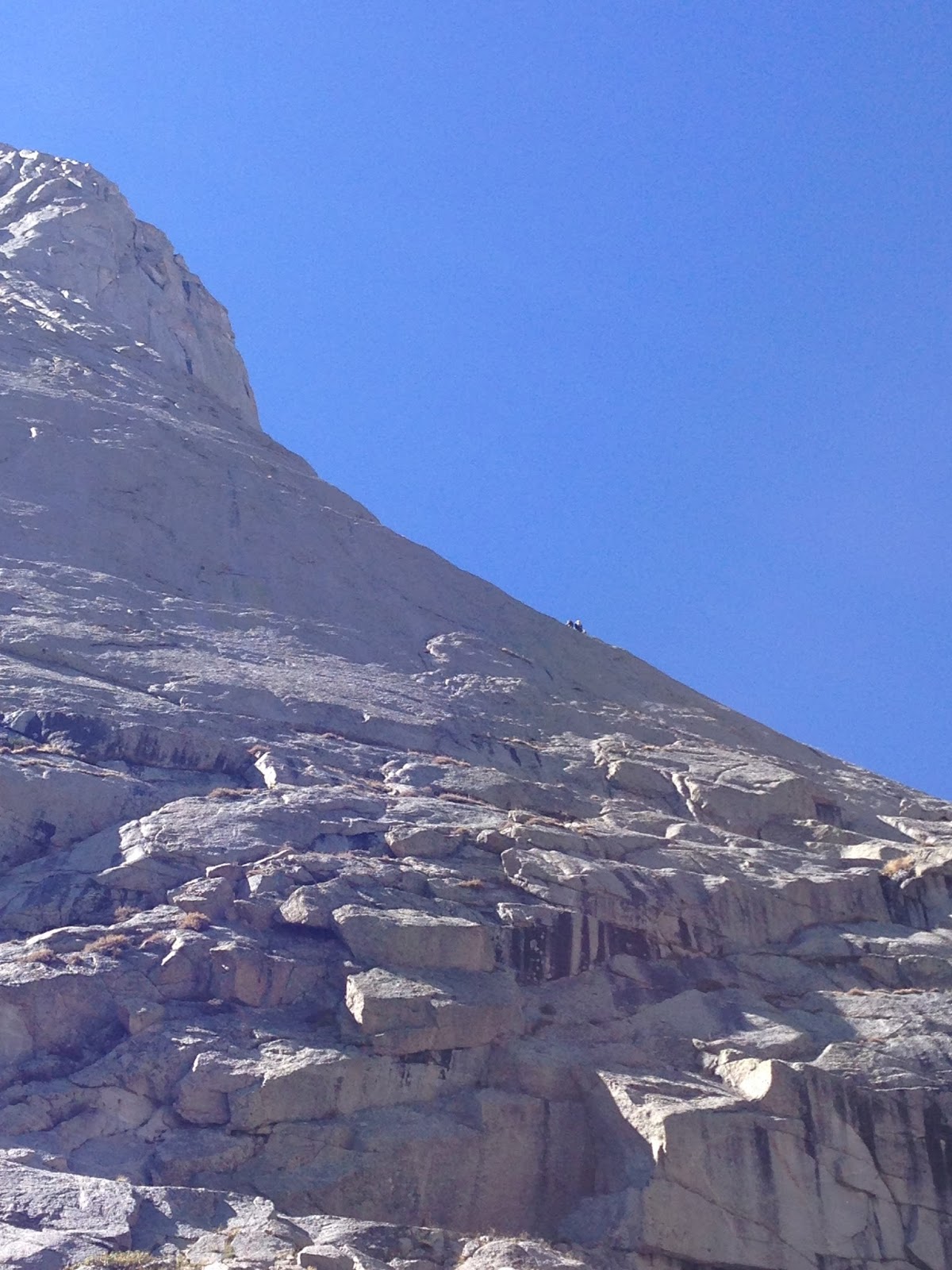
Climbers on the NE face route (skyline)

Lonesome Lake and Mitchell Peak from Pingora.
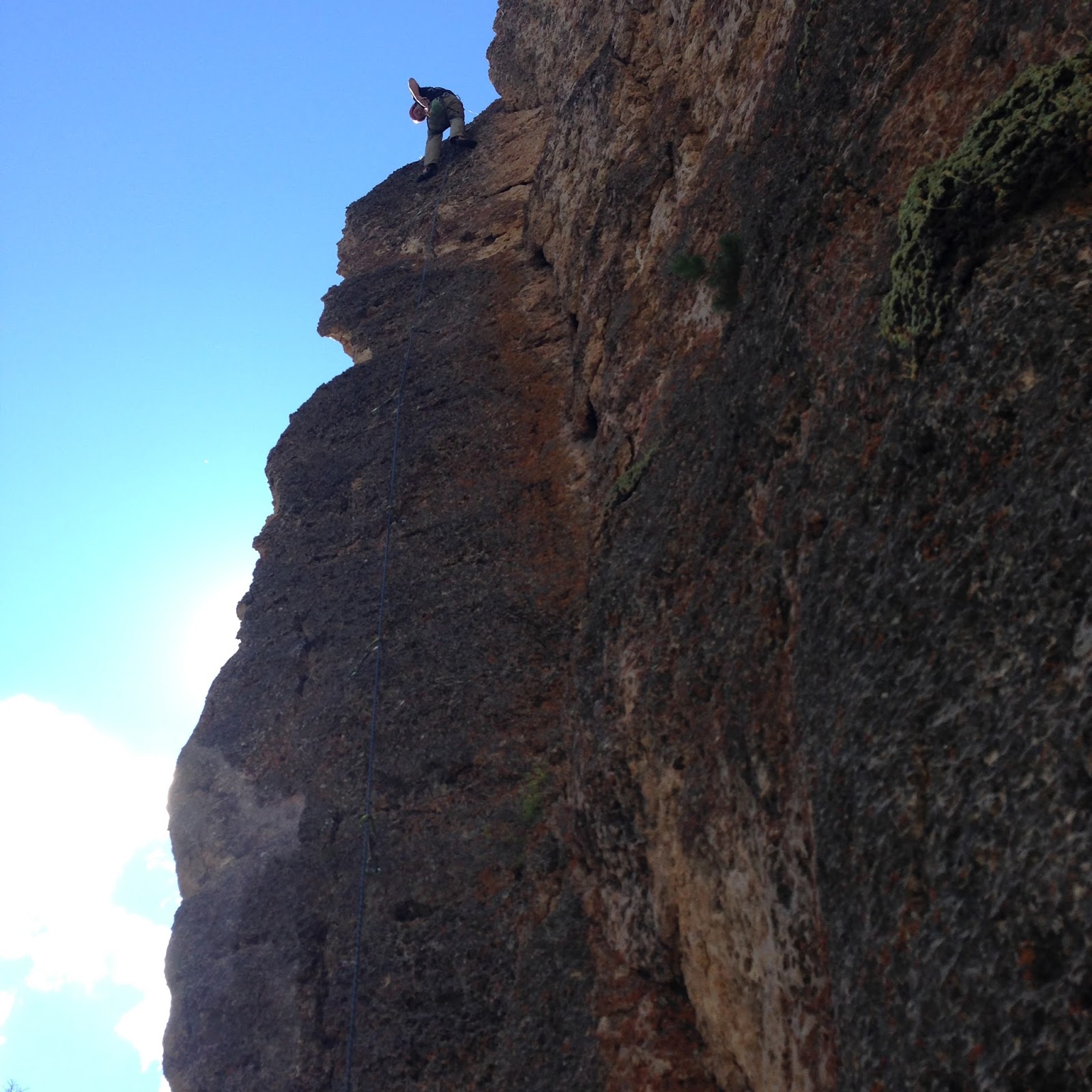
Climbers bailing from the first pitch. The silhouettes made for great photos that I failed at taking. Warrior 1 (?) in the background. 


I might have Warbonnet and Warrior 1 mixed up. 
More ice than snow actually. Verglass.
The cirque to the N of Pingora and Wolfs Head. 
The route traverse to the left skyline and on to the top. 


The NE face route essentially goes up Pingora's right skyline. 

Pingora and Wolfs Head.
Whether its called Warbonnet or Warrior 1 (or 2) I want to climb it.  Definitely the most intimidating but doable climb out there. 
On our way back; Haystack, East Temple and Wind River peaks visible. 
A little bubbly will make anyone smile. 


Friday, September 18, 2015

Wyo Road Trip: 3of4 Sinks Canyon

Sinks Canyon lays directly en route to the Wind Rivers so naturally we had to stop and say hello. We found a beautiful campground on the Popo Agie river to spend a night. Again, we didnt have any guide books so off we went hoping to onsight. With a little beta from Mountain Project, we knew there was an area of limestone that had a high concentration of moderates. We ended up parking at the western most (almost) end of the cliff band and traversed the entire thing left to right before we found the Scud Wall. The classics were occupied so we hopped on a 5.11 to get to some chains and top roped a 'silly' 5.10. We left it at that because we had a lot of driving to do to get to the Big Sandy trailhead in the Wind Rivers.
The Popo Agie right next to camp.
A large portion of the Limestone cliff band
Shelly, our chariot for the week. Never had a problem, never left us stranded. 
A crazy cave with tons if super human routes. 


Not often you look at a 5.11 and think it looks easier than a 5.10 but we fell victim. 
A climber working the roof on one of the classics of the area. 

Wednesday, September 16, 2015

Wyo Road Trip: 2of4 Ten Sleep

Since our other 2 50-classic route objectives are in the Wind River range, we were hoping to spend the rest of the week there. However a cold snowy forecast changed our game plan completely. Not a big deal though, Wyoming has a little bit of everything. Actually, it has a lot of everything! Ten Sleep Canyon in the Big Horn mountains is quickly becoming the sport climbing mecca of the NW. I had been there once prior but Sam had not so it was an easy decision to spend a couple of nights there. Without a guidebook, but with a little help from Dirty Sally and some Oregano's (people from Oregon) in town climbing, we were able to semi-orient ourselves in this miles long canyon. It rained Wednesday but we were able to climb 3 routes on the Lonesome Wall, a 5.8, 5.9, and 5.10b/c. The next day we went up to the French Cattle Ranch area, more specifically the Big Kahuna Pillar, and found 4 more routes in our realm. Never figured out what one of them was but it was the hardest send of the day and Sam lead it; a 10 bolt ramp up there somewhere. Then I found a crack with a 5.10 chalk label at the base and lead it without difficulty. Then I lead another long 5.9 ramble to the right, clipping three different sets of chain anchors as I kept climbing/traversing. This last anchor is over a new dirty route that we top-roped before hitting the road to Thermopolis and eventually Sinks Canyon. Onsight climbing is always a little extra exciting. Kicked a bull moose off the trail on the way out.
The North side of this chunk of the Lonesome Wall stayed dry while it rained. 
Eventually the South side dried enough to climb the 5.8 this chick is climbing. 
I think this was the hardest route we did, no idea what its called or rated. 
A super fun 5.10 crack start to pockets.
MTs owning the base of the craig.
Some of the super human routes on the French Cattle Ranch.

Is he looking at me or away from me?

Monday, September 14, 2015

Wyo Road Trip: 1of4 Devils Tower aka Bearlodge

Sam and I took off for a week in Wyoming hoping to climb 3 of Steve and Roper's (America's) 50 classic climbs. Long story short, we only got one. Obviously we still had a blast though. The first stop on the agenda was the 600' Devil's Tower. The Durrance route is the classic and goes at 5.8, 6 pitches if you dont link up some of the short ones. Somehow we had it entirely to ourselves! I linked pitches 3 and 4 as well as 5 and 6. Nobody on lead actually jumps the jump traverse, dont kid yourself (pitch 6). We climbed the South facing route in 87* weather with no wind or clouds; got a little warm up there. We killed half of our water just getting to the base of the climb! Oops! But we got to the top and Sam was extra excited to get his next biggest climb done (we climbed the Wedge a week prior). I was hoping to give El Matador a go the next day but I felt like I had climbed a mountain in Patagonia... sore! The Durrance route isnt so much rock climbing as it is mountaineering. I had fun and recommend it but I doubt Ill go back up it. Theres too many lines to really ever repeat something on the Tower.
Sam following the Durrance Cracks (P2). This was really the only pitch that demanded rock skill.
While I was belaying Sam up P3 and P4 (linked), a little dove whispered sweet nothings in my ear. 
Sam on the summit overlooking the visitor's center. 
The summit is a 1 acre grassy top/field.


The Durrance route is easy to spot: see the leaning column in the far left of the photo? You climb that (P1) and basically follow a procession of column tops.